 |
 |
 |
 |
 |
 |
General Phoenix Climate InformationWinters are mild and snow is extremely rare. Early morning lows are among the coolest in the metropolitan area. However, late winter afternoons commonly are the warmest in the entire region outside of Buckeye. Summer afternoons are hot. Average high temperatures equal or exceed 100°F from mid-June through mid-September. Fog is uncommon but appears more frequently and persists longer than in most of the metro area. Winds tend to be light year round. High winds sometimes occur when strong fronts or strong thunderstorms move through the area. Dust storms occasionally blow in from the dust prone agricultural regions of the county. Most precipitation falls in late-winter/early-spring showers or in summer thunderstorms. Late-spring/early-summer is usually exceptionally dry. Average yearly rainfall is 8.50 inches. The most uncomfortable time of year is early July through August. During this period, the summer monsoon extends northward over the southwestern United States and moist tropical air moves over Arizona combining relatively high humidity with very high temperatures. This also leads to scattered afternoon thunderstorms over the Mogollon Rim and the White Mountains with thunderstorms every so often redeveloping over parts of Phoenix during the evening or at night. Severe Weather Hazards Table of Contents:Thunderstorm Facts Thunderstorm FactsThunderstorms are most likely to happen during the spring and summer months, and during the afternoon and evening hours when thermal radiation from the earth forces hot surface air up into cooler moist air. During the Arizona monsoon season which is typically from July 4 through September 15, thunderstorms most commonly form over the higher terrain during the late morning and early afternoon, then move into the lower elevations, such as the southwest deserts, during the late afternoon and evening hours. In most cases monsoon thunderstorms are over by midnight. Thunderstorms affect a relatively small area compared with hurricanes and winter storms. The average diameter of a thunderstorm is just 15 miles and lasts just 30 minutes. Despite their small size, all thunderstorms are dangerous. However, only about 10 percent are considered severe. By definition, the National Weather Service considers a thunderstorm severe if “it produces hail at least _ of an inch in diameter, winds 58 mph or greater, or tornadoes.” Even if a storm is not severe, it can produce dangerous, sometimes deadly, conditions such as lightning, hail, flash flooding, dust storms (a.k.a. haboobs), or strong straight-line winds including microbursts and macrobursts. Thunderstorm Phenomena
Downbursts
Known as either “microbursts” or “macrobursts” (when the microburst occurs on a much smaller scale in terms of time and aerial coverage), downbursts can be one of the most damaging phenomena generated from thunderstorms. In extreme cases, downburst winds can reach speeds equal to a strong tornado which may or may not be accompanied by rain. Downbursts are known for the creation of what is known as “straight-line winds.” Straight-line Winds
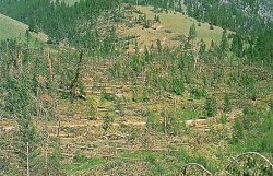
These devastating winds can exceed 100 mph and can flatten building and forested areas in a matter of seconds. They are generated from downbursts and are responsible for most thunderstorm wind damage. Hail
Hail causes nearly $1 billion in damage to crops and property annually. Large hailstones fall at speeds faster than 100 mph. Hailstorms can be extremely dangerous if trapped, but due to their short lived nature casualties remain minimal. Tornadoes
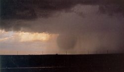
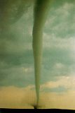
Tornadoes are nature’s most violent storms. Winds can exceed 200 mph and most damage is caused by circulating debris picked up by the high winds. Tornadoes in Arizona are rare and generally are classified as weak (69 percent of all tornadoes are in this classification). Weak tornadoes last between 1 to 10 minutes and have winds less than 110 mph. Flash Flood Facts
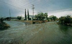
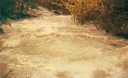
Flash floods are the number one weather related killer in the United States. Several factors contribute to flash flooding. The two key elements are rainfall intensity and duration. Intensity is the rate of rainfall, and duration is how long the rain lasts. Topography, soil conditions, and ground cover also play important roles. Flash floods occur within a few minutes or hours of excessive rainfall, a dam or levee failure, or in some parts of the world, a sudden release of water held by an ice jam. Flash floods can roll boulders, tear out trees, destroy buildings and bridges, and scour out new channels. Rapidly rising water can reach heights of 30 feet or more. Flash floods producing rain can trigger catastrophic mud slides and land slides. There is little warning that these deadly, sudden floods are coming. It is important not to underestimate the power of water. Six inches of fast-moving water can knock you off your feet. A depth of two feet will cause most vehicles to float. Most flash flood deaths occur at night and most victims are trapped in cars. The two types of flash floods that can occur in the Phoenix area are urban floods and arroyo/wash floods. As land is converted from fields, woodlands or deserts to road and parking lots, it loses its ability to absorb rainfall. Urbanization increases runoff 2 to 6 times over what would occur on natural terrain. During periods of urban flooding, streets can become swiftly moving rivers, while basements can become death traps as they fill with water. An arroyo is a water-carved gully or normally dry creek bed (ex. Salt River). Arroyos can fill with fast-moving water very quickly. Flash flooding at some arroyos can take less than one minute to develop. Lightning Facts
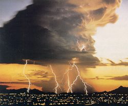
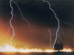
Lightning results from the buildup and discharge of electrical energy between positively and negatively charged areas. The action of rising and descending air within a thunderstorm separates positive and negative charges. Water and ice particles also affect the distribution of charge. Most lightning in a thunderstorm occurs within the cloud but a good amount hits the ground. The air near a lightning strike is heated to 50,000 degrees F (hotter than the surface of the sun). The rapid heating and cooling of air near the lightning channel causes a shock wave. Thunder is the result of that shock wave. While the average person’s chances of being struck by lightning are 1 in 600,000, certain safety precautions can be taken if you are caught outside:
To determine how far away lightning is to your location, perform the following calculation. Count the number of seconds between a flash of lightning and the next clap of thunder. Divide this number by 5 to determine the distance to the lightning in miles. Dust Devils
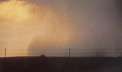
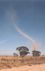
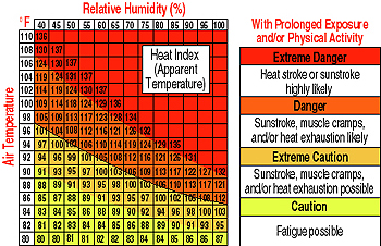
Dust Devils are rapidly rotating columns of air, usually about 100 to 300 feet in height, that get their appearance by picking up dust, straw, leaves or other light debris as they skim across the ground. In some cases, stronger dust devils can reach heights of 1000 feet or more. Dust devils may rotate either clockwise or counter-clockwise, and generally do not exceed speeds of 30 mph. Although most dust devils are not highly dangerous, stronger ones can reach wind speeds in excess of 50 mph and can become hazardous to light aircraft or other light vehicles. Severe cases of dust devils can cause minor damage to houses and trees. Dust devils are not the same as, or as dangerous as, tornadoes. Dust devils usually develop on calm, hot afternoons with clear skies, mostly in desert regions, and they have no relationship to large-scale dust storms. They develop from superheated air over the ground, especially flat, bare surfaces. A thermal of hot air starts to rise, and surrounding air from diverse currents flows in to equalize the pressure difference and an eddy of whirling winds is started which ascends in spiral form. Heat Index (A Guide for Calculating the “Real” Temperature)In most parts of the country, people look forward to summer months. In the desert southwest, however, the summer months are brutal. With maximum temperatures generally between 105 and 110 degrees in the Phoenix area, fatigue, heat stroke and sun stroke are not uncommon threats to people engaging in prolonged outdoor activity. This is especially true during much of July and August when tropical moisture enters the Arizona atmosphere. The term “Heat Index” is an apparent temperature based on the actual temperature and the amount of moisture in the air. Just as an increase in wind makes cold air more unbearable (known as “wind-chill factor”), an increase in moisture makes hot air more uncomfortable. The Heat Index Graph, as shown below, was devised by the National Weather Service and uses temperature and humidity values to determine the heat index.
|
||||||||||||||